Nakhind is a hill, 704m high, situated north of Peb fort. The top is a
narrow forested ridge, running in the north-south direction. It can be identified by a hole at its northern end, which is
visible even from trains travelling to Karjat. The highest point of the ridge is in its centre. The ridge descends to a hump
where it meets Peb fort. Electric power lines cross the Matheran range at this hump from Neral to Panvel. A more interesting
trek to Nakhind would be to traverse the top of Nakhind from its northern end to its southern end (Peb fort hump junction)
passing right in front of the hole.
This is a great trek in the monsoon or in the winter.
One can approach the northern end of Nakhind from Vangani station. Turning west from Vangani station, one can walk to Vangani
village and from there after walking across some fields, an easy route climbs up to reach a plateau at a height of 300m. A
small village is situated there. In the monsoon one passes across a few waterfalls on the way. From the village a track climbs,
a bit steeply at times, up the mountain approaching the northern end of its top ridge. The track reaches the northern tip
of the top ridge. It takes about three hours to climb to this point from Vangani station. From here one can start walking
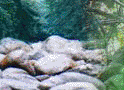
south for the traverse. After walking for about fifteen minutes one reaches the hole. It is a grand sight, standing
in the hole, with a view of Konkan both to the east and the west. Also the wind blows extra strong in the hole. Traversing
ahead from the hole leads in about fifteen minutes to a 4m high rock climb. This rocky patch cannot be climbed from the ridge
end. Instead one has to go around to its east from where one can climb it. But this side is a bit exposed and it would be
advisable to use ropes, particularly in the monsoon. The highest part of the climb involves a tricky exposed move around a
big rock.
After negotiating the climb, the route continues south on the top ridge. One or
two easy rocky patches have to be climbed initially, but after that it is a gentle ridge walk. The ridge climbs up to its
highest point and descends to meet the hump near Peb fort. The route passes through forested stretches and is great fun in
the monsoon with strong winds blowing. At some point the route suddenly turns left (east direction) and descends rather steeply
along the east side of the mountain to lead onto the hump near Peb fort, from where one can descend to Neral. It takes about
one and a half hours to reach the hump from the rock climb, and about two hours to reach Neral from the hump.